ملف:Bravo fallout2.png
اذهب إلى التنقل
اذهب إلى البحث
حجم هذه المعاينة: ٨٠٠ × ٣٦٤ بكسل. البعدان الآخران: ٣٢٠ × ١٤٦ بكسل | ٩٢٨ × ٤٢٢ بكسل.
الملف الأصلي (٩٢٨ × ٤٢٢ بكسل حجم الملف: ٢٣ كيلوبايت، نوع MIME: image/png)
ملخص
| الوصف |
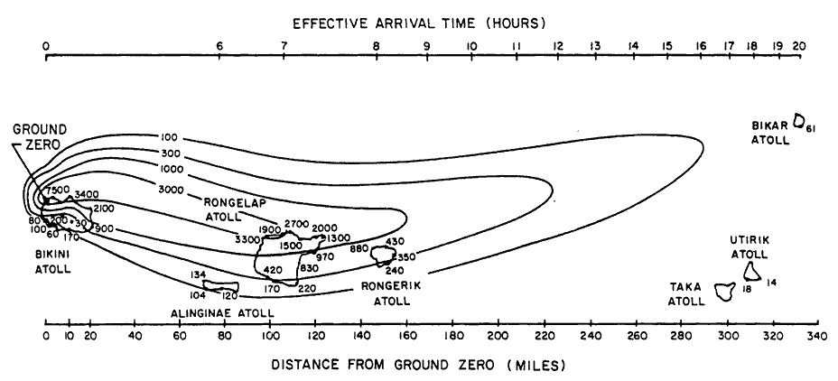
English: Path of nuclear fallout plume after U.S. nuclear weapons test Bravo (yield 15 Mt) on Bikini Atoll. It is the single worst contamination accident in U.S. nuclear history. The test was part of the Operation Castle. The Bravo event was an experimental thermonuclear device surface event. The numbers correspond with estimated total (accumulated) dose contours (rad).
Suomi: Ydinkoe Bravon (räjähdysvoima 15 Mt) radioaktiivinen laskeuma. Bravo testi on Yhdysvaltojen pahin ydinonnettomuus. Testi oli osa Operaatio Castlea. Bravo räjäytys oli kokeellinen fuusioreaktioon perustuva pintaräjäytys Bikinin atollilla. Kuvan numerot kuvaavat arvioituja kertyneen kokonaislaskeuman rajoja (rad). |
| التاريخ | |
| المصدر | Samuel Glasstone and Phillip J. Dolan, eds., The Effects of Nuclear Weapons, 3rd. edn. (Washington, D.C.: DOD and DOE, 1977): 437. [Gamma doses are Roentgens from arrival time to 96 hours (4 days) after detonation, outside on land. Glasstone and Dolan mention that because data from the ocean was not obtained in this particular test, Bravo, the fallout contours to the north of the islands are uncertain and some other fallout patterns for the same test ascribe the high levels measured on Rongelap to a "hotspot" of the sort measured in the ocean downwind in later tests. |
| المؤلف | United States Department of Energy |
| إصدارات أخرى |
 |

|
هذه graph الصورة / الصورتان باستعمال رسومات متجهية ملفات رسوميات شعاعية.
It is recommended to name the SVG file "Bravo fallout2.svg" - then the template Vector version available (or Vva) does not need the new image name parameter.
|
ترخيص
| هذا عملٌ مِن إنتاج مُوظَّفٍ في وزارة الطاقة الأمريكيَّة (أو إحدى المُنظَّمات التابعة لها) التُقط أو صُنِع خلال أدائِه لواجباته الرسميَّة .بصفته عملاً للحكومة الاتحادية للولايات المُتَّحدة الأمريكيَّة، فإنَّ هذا العمل يقع في النِّطاق العامِّ.
يُرجى الانتباه إِلى أنَّ المُختبرات القوميَّة تعمل وفقاً لرخص مُتنوِّعة بعضُها قد لا يكون حُرَّاً. تحقق من سياسات المختبر قبل أن تستعمل هذا الوسم.
|

|
تاريخ الملف
اضغط على زمن/تاريخ لرؤية الملف كما بدا في هذا الزمن.
| زمن/تاريخ | صورة مصغرة | الأبعاد | مستخدم | تعليق | |
|---|---|---|---|---|---|
| حالي | ١٨:٢٥، ١٠ ديسمبر ٢٠٠٥ | | ٩٢٨ × ٤٢٢ (٢٣ كيلوبايت) | wikimediacommons>Fastfission~commonswiki | Image of nuclear fallout dispersal from the Castle Bravo nuclear test, 28 Feb 1954. ==Licensing== *Source: Samuel Glasstone and Phillip J. Dolan, eds., ''The Effects of Nuclear Weapons'', 3rd. edn. (Washington, D.C.: DOD and DOE, 1977): 437. {{PD-USG |
استخدام الملف
لا توجد صفحات تستخدم هذا الملف.